The Kgalagadi National Park is Africa’s first transfrontier national park, the result of merging the Kalahari Gemsbok Parks in Botswana and South Africa and incorporating Mabuasehube on the eastern Botswana side of the park. The Kgalagadi comprises an area of over 3.6 million hectares or approximately 2.5 million square kilometres.
Kgalagadi means ‘land of thirst’ and the huge, desert landscape is part of the Kalahari Desert – the largest continuous area of sand in the world. Red sand dunes, dry riverbeds and sparse vegetation characterise the Kgalagadi

Kgalagadi means ‘land of thirst’ and the huge, desert landscape is part of the Kalahari Desert – the largest continuous area of sand in the world. Red sand dunes, dry riverbeds and sparse vegetation characterise the Kgalagadi

The annual rainfall is 200mm, mainly between January and April. The summer day temperatures may exceed 40 degrees Celsius yet the night time winter temperatures plunge well below freezing. Visitors should expect extreme heat during the day and extreme cold during winter nights. The last four months of the year are hot, dry and dusty. Then dark clouds start to build up and the wildebeest begin to calve in anticipation of the heaviest rainfall between January and April. In the Mabuesehube after heavy rains herds of eland, hundreds strong can be seen. Following a tremendous thunderstorm and even hail occasionally the dry rivers begin to flow for a brief period.


The birdlife is typical of the dry Kalahari woodlands and as with any dry habitat, birding opportunities vary according to rainfall. 260 bird species have been recorded in the Kgalagadi and the birds of prey are particularly interesting. There are a wide selection of waterbirds due to the sudden transformation of the park after a thunderstorm. More than 50% of the birds are vagrants or irregular visitors. After good summer rains, temporary avian inhabitants may include large flocks of storks and sometimes even a few flamingos, ducks, flufftails, sandpipers or a crake or two.

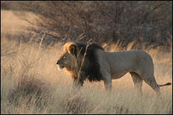
It is renowned for predator watching and home to black-maned Kalahari lions, leopards, cheetah, brown and spotted hyaena, wild dog, black backed jackal, gemsbok, blue wildebeest, eland, springbok, red hartebeest, duiker and steenbok. It is estimated that there are 450 lions in the park and to survive in such harsh conditions the large carnivores have to adopt wide-ranging tactics. This includes a variety of smaller than usual prey in their diet and a huge range over thousands of square kilometres as prides often split into smaller hunting groups.
Visitors should be totally self-sufficient in fuel, water and food, although water can sometimes be obtained from the Game Scout Camp.
The roads are dirt and are quite sandy in parts but a 4WD will only be necessary during the wet winter months. Due to the remoteness of the area it is advisable to travel in a convoy of at least 2 vehicles.
Light aircraft may land on a tarred runway at Twee Rivieren but prior permission must be obtained from the Park Warden.
It is currently not possible to cross from Namibia at Mata Mata or Union's End.
Where to Stay
Two Rivers Camping Ground – situated near the entrance gate. Currently has three undeveloped campsites.
Rooiputs Camping Ground – situated 25km up the Nossob River Valley from the entrance gate. 6 individual campsites. Presently no facilities available.
Poletscua Camping Ground – situated in the northern section of the NossobValley. 3 undeveloped campsites.
Mabuasehube Area – situated in the extreme east of the national park. A number of individual campsites overlooking the pan, some of which have small waterholes. Some have picnic tables.
Mabuasehube Pan – 4 campsites with pit latrines and small waterhole.
Mpaathuthva Pan – 2 campsites with pit latrines and a small waterhole
Khiding Pan – 2 campsites with pit latrines
Lesholoago Pan – 1 campsite with pit latrine and 1 campsite without. Small waterhole.


No comments:
Post a Comment